Friday, July 19, 2013

Nederland to Crested Butte - Day 2

Day 2 was quite different than Day 1; less than half the mileage, but with 3 passes to climb instead of 1, and (here's the best part) with 20+ miles of single track. The route started from Copper on segment 8 of the Colorado trail, and ended with another night of camping well west of Leadville, most of the way up Hagerman Pass.

First though, we had to load up with food and water for the day by backtracking to the convenience store at the I-70 exit near Copper, which didn't open until 7 AM. We didn't get the early start we wanted, but sleeping in has it's advantages:

The morning resupply turned out to be a blessing in disguise. We were able to score hot burritos and coffee for breakfast, which was very welcome. Rob even got two burritos and carried one with him. The convenience story had a real coffee shop next door, which we didn't realize until we had already settled for convenience store coffee. Oh well, it was hot, that's the main thing.

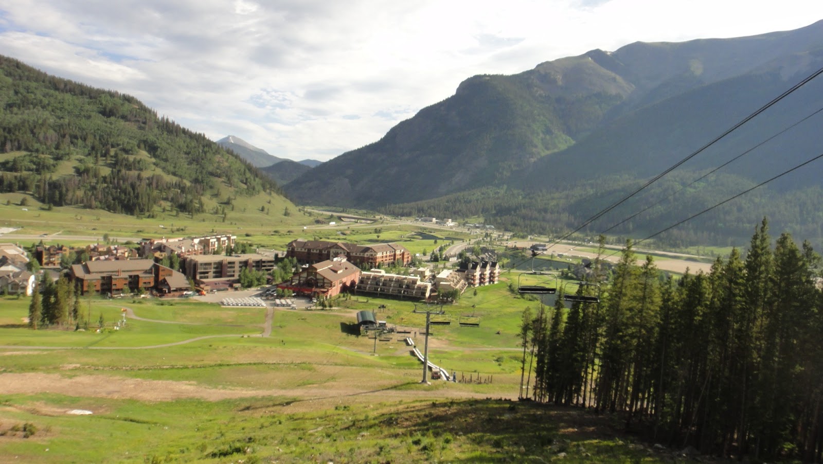
Loaded up with food and water, we headed back to the Colorado Trail trail head and commenced the long climb to the first pass of the day, Searle Pass. The trail climbs through the Copper ski area, under a few of the lifts:
At some point the morning chill dissipated, the muscles got warm, and I called out a stop to remove leg warmers and jacket, and apply sunscreen. Rob took the opportunity to make some business calls as we still had cell phone signal from Copper. For Rob, this was a working vacation in more ways than one:

The climb started out nice but as we got higher we saw more and more steep sections which, with tired legs, heavy bikes, and many miles still to go, warranted getting off and pushing:

At some point, I noticed my rear tire (the one I flatted and repaired on Day 1) was soft, so I began to ride more attentively, and noticed the occasional hiss of escaping air.  Taking a look, it was clear I had punctured again right at the same place I cut my tire the previous day. The leak was slow, it appeared the residual Stans in the tire from my previous tubeless installation was trying to seal the puncture in the tube, so I elected to just add some air and keep going, delaying more drastic action until absolutely necessary.

At the top of Searle Pass at 12,000 ft. we ran into some company. These guys were fun to talk to (and share Twizzlers with), they were Specialized bike industry guys from Europe, specifically Portugal, Italy, and Poland. As part of their job, they were staying at Copper trying out 2014 model year bikes for Specialized. Unlike us, they were just out for a day ride and turned around here at Searle Pass to go back to Copper and (presumably) drink beer. Beats my desk job! They asked what the altitude was here, and we had a bit of fun trying to convert feet to meters:

Another view from Searle Pass, looking west in our direction of travel. Our next supply opportunity, Leadville, is somewhere beyond the horizon, and my bike is urging me on:

Past Searle, the next milestones are Elk Ridge and then Kokomo Pass. Kokomo Pass is the same altitude as Searle, at 12,000 ft. but Elk Ridge is actually the high point at 12,300 ft. From Searle we were forced to drop a bit before climbing again to Elk Ridge. Here Rob crosses one of many streams as we approach the high point:

I love this picture, the trail climbs relentlessly up to the ridge:

And here's Elk Ridge, the high point of the day at 12,300 ft. At this point, it's a long technical downhill through Kokomo Pass towards HW 24 leading to Leadville. My rear tire had been continuing to leak slowly and was too soft to ride the downhill without damaging the rim, so I elected to put in another tube at this point. Thankfully the weather held here above tree line while I worked, again with Rob's help:

One of the easier parts of the downhill just past Kokomo (which is why I was able to get the camera out):

After a long decent (during which my wounded tire held together, thankfully) we paused to rest the hands after some aggressive braking and realized we were both low on water. We found a stream, filtered about 40 oz. of water apiece, and continued on. After more downhill, we bottomed out at the old Camp Hale barracks where the 10th Mountain Division lived and trained during WWII. An interesting side note, camping is not allowed here due to the risk of unexploded ordinance:

While the Colorado trail continues on, roughly parallel to HW 24 towards Leadville, we elected to bail to the highway early, partly to save energy, partly due to my tire, and partly due to what appeared to be weather moving in.  Once on pavement it was a long haul south, initially up to Tennessee Pass, then a long slight downhill with rollers into Leadville.  Here's Tennessee Pass, the second divide crossing which put us back on the Atlantic side of the continent:

We saw some pretty good rain just past Tennessee Pass, during the next hour or so it took to get into Leadville. All rain gear got used, including jacket, pants, and in my case, water-proof over-gloves.

Finally, we rolled into Leadville, stopped immediately for a Gatorade and did the usual smart phone research. I decided not to chance my rear tire any further, so we needed a bike shop to do the work, followed by food. The local bike shop on the far south end of town got a new tire installed for me, set up tubeless, and the friendly folks there recommended a pizza place just down the street called High Mountain Pies. Man it was good! Rob and I got a 14" pizza apiece and proceeded to get to work:

With full bellies and improved morale, we packed up what little pizza we had left over, headed back north through town, loaded up with food and water at a grocery store, then set off west towards Turquoise Lake to find a place to camp:

We saw a nice sunset starting just past the Turquoise Lake dam:

Out initial plan was to camp in this area, near Turqouise Lake. However, perhaps due to the excellent pizza, we were feeling pretty decent and decided to keep rolling. We rode a good hour past sunset and made good progress up the next climb, Hagerman Pass. Unfortunately, the price of our ambition was we passed up all the good camp sites, so we had to settle for a spot near a drainage right beside the road. However, given it was jeep trail at this point, no one came by overnight to bother us.

Tomorrow - our final divide crossing at Hagerman Pass, to Basalt, then Aspen. Continue reading, day 3.

Nederland to Crested Butte - Day 1

Big mile day! The route for day 1 took us from camp near Rollinsville all the way to Copper Mountain, about 102 miles for the day. It started with the climb up and over Rollins Pass to Winter Park, which Rob and I had done many times. However, once we started heading west out of Frasier, I was in all new territory (Rob was too, for the most part).

Here we are headed west on Tolland Road with nice long shadows from the rising sun:

Right as the sun was finally starting to warm us up, I caught some elk on the run:

Here we're about to start up a jeep trail, Rollins Pass Road:

This is a really cool area with a fascinating history. Down Moffat Rd is the east end of the Moffat Tunnel, which goes underground more than 6 miles, crossing the divide. Before this tunnel was built, the old railroad climbed up and over the divide via a long indirect route full of switchbacks. The tracks are long gone, but the old railroad bed is now a jeep trail. Jeeps can't get all the way over the divide this way through, due to a few collapses along the route, but an ambitious MTBer can.

Here's Rob turning up one of the many switch backs up Rollins Pass road:

A quick stop for a proper (relatively speaking) breakfast:

Yankee Doodle Lake:

A bit of snow prior to the Needle Eye tunnel:

Nice view ahead to the Needle Eye tunnel, you can see the light at the end of the tunnel (literally, but definitely not metaphorically, we still have 250 miles to go). The old railroad used to go though this tunnel, but it's partly collapsed now:

Another blockage prior to the tunnel, gotta get off the bike:

Looking back at Rob as we both approach the tunnel. Above tree line here:

And the tunnel. Gotta scramble over and through the scree and alpine tundra. Having everything on the bike and no backpack is great 95% of the time, the other 5% being hike-a-bike sections like this:

Past the tunnel are some old trestle bridges:

Approching Rolllins Pass now, it's just past this snow field. It will be our first divide crossing of the trip and our high point for the day at 11,700 ft:

On the Pacific side of the divide now, that's the Winter Park ski area way ahead:

Crossing one more trestle bridge. This one is even more inadvisable to use, it's poor condition is obvious. I realize now I crossed right behind Rob, I really should have spaced out more to minimize total weight on the bridge. Oh well, we made it:

For fun, here's a picture of this trestle from below when it was operational:

Lunch at Winter Park. A big sandwich, a double-helping of cole slaw, and a brownie. Rob got a Coke, I was jealous:
Next we went north to Frasier (nice bike path for this stretch) then started a very long haul west towards highway 9. This route was half forest service road, half pavement. It didn't get very high, so it was pretty hot. Here's a representative view of the FS road:

Just before the road changed from dirt to pavement, I flatted. As per usual procedure, once I heard the hissing of escaping air, I jumped off the bike and turned the rear wheel to put the puncture on bottom, and waited for Stans to seal the puncture, but no luck; I just got a nice white puddle of sealant on the ground. Turns out, I had a nice 1/4" cut in the tire, not sure what caused it, but hey, it happens. Rob pitched in (partly because he's a nice guy and partly because he was the one carrying flat repair stuff), and when he pulled out his can of air, it was dead. We were stuck with his mini-pump, which is probably the smallest pump ever. Regardless, we got the tire booted, a tube in place, inflated (quite the upper body workout, let me tell you), and kept rolling.

At some point during the paved road section (did I say it was hot?), we got a good view of the East Branch Reservoir. Not that impressive really:

Finally, a view that gave us a sense of progress. The valley ahead is HW 9, you can just make out the cars:


After a fast and breezy decent to the valley, we struck south on HW 9 towards Silverthorne.  After almost an hour of spinning next to traffic, we arrived in town:

Once in town, Rob looked up the closest bike shop on his smart phone, which was in Dillon across I-70. We walked in, the main reason being to replace Rob's can of air. While here, I decided to do something about the fact that I was rapidly exhausting the supply of chamois cream I brought with me. I'll spare you details, but suffice to say that saddle issues have been my weakness in the past. I started this trip with brand new shorts and what I thought would be an adequate supply of chamois cream, but I had calculated wrong. I ended up buying a full size 8 oz tube of Paceline Chamois Butter, and I carried it the entire trip. It was annoying to make space for it (I had very little to spare), but this turned out to be a life saver. By the end of the trip, the tube was 2/3 empty but I remained happy and comfortable. If the butt ain't happy, ain't nobody happy.

After leaving the bike shop, we connected into Frisco via the Dillon Reserior Dam and a scenic stretch of bike path that I hadn't ridden before. Climbing up to the dam:

Along the dam:

Connecting to Frisco:

Once in Frisco we looked for a place to eat dinner. Throughout this trip, our criteria for where we ate were simple. The food had to be good, the quantities large, the cachet non-snooty (some places in Basalt and Aspen failed this test), and outdoor seating was preferred, so we could keep an eye on the bikes. We found a place called The Lost Cajun, run by a Hurricane Katrina refugee from Louisiana, so the food was authentic and really good. Unfortunately the large order of beignets we got for dessert didn't make the picture, but my etoufee with fried catfish on top did:

After dinner, next on the agenda was loading up with supplies for tomorrow and finding a place to camp. We figured the best place to camp would be the beginning of segment 8 of the Colorado Trail, which was our route for tomorrow. This starts right by Copper Mountain, about 5 miles or so SW of Frisco. We had resupply opportunities in Frisco, but we knew there was a convenience store next to Copper, so we decided to hold out, carrying less weight for the slight climb to Copper. We saw some geese on the way, a rather mundane wildlife sighting for a back country trip like this:

Just ahead is the Copper Mountain ski area, the convenience store is close as well. However, it was closed! The current time was 8:30 PM, the store closed at 8. Odd hours for a convenience store... As a last resort we continued on into the Copper Village area, but it was shuttered up tight too:

After some discussion, we decided we had to abandon our plan of a early start on the Colorado Trail, but instead hit up the convenience store when it opened at 7 AM. As long as we moved with a purpose on day 2, we figured we could still get through the high country before the afternoon storms rolled in. So, we went south a mile or two on HW 91 to the Colorado Trail trail head and found a place to camp, right off the trail and near a partially finished outbuilding:


Tomorrow - some sweet single track and triple pass action! Continue reading, day 2.

Thursday, July 18, 2013

Nederland to Crested Butte - Day 0

As mentioned in the summary, we revised the original plan to take the bus from Boulder to Ned and ride a few extra miles out of Ned to find a camping spot. This was a fine way to kick off the trip, and it shaved a few miles off of Day 1, which ended up being a 100+ mile day anyway, with 9000 ft. of climbing.

What a deceptive way to start a hard trip!  An air-conditioned ride in a bus, a nice BBQ dinner and craft beer at the Wild Mountain in Ned, followed by an easy spin south on HW 119. Food is one of the most important and enjoyable parts of a trip like this, so I made a point of documenting comestibles on this trip, but I missed this meal. However, I did catch Rob enjoying desert after he grabbed Twizzlers at a convenience store on the way out of town:

Rob actually had these Twizzlers all the way through the Colorado Trail well past Copper, he must have gotten tired of them because he was handing them out to other trail users.

We saw a very nice sunset south of Ned, just one small example of what makes a trip like this worth it. We'll be crossing that mountain range in the background, and the two that follow it as well, before this trip is done:

After some hunting and pecking we found a nice spot to crash for the night, near some USFS outbuildings. That's my Tarptent Contrail on the right, half set up, with a 2 mil plastic sheet as a foot print. This was my first trip to use this tent (I did practice with it a bunch in the back yard though), and I loved it.  One and a half pounds, roomy, with space to sit up and dress, and it packs small. It's single wall, so you have to avoid touching the walls (they get wet), and it's not free standing, but the positives outweigh these concerns. I highly recommend it. I've got better pictures of it later:

A few more Twizzlers, then beddy time. Big day tomorrow! Continue reading, day 1.

Nederland to Crested Butte - Ride summary

Earlier this year I was invited to be part of an ambitious bikepacking trip planned by my friend Rob, a 4 day, self-supported trip from Boulder to Crested Butte. In the tradition of bikepacking, we would carry all we needed (shelter, clothes, bike repair stuff, etc.) and resupply with food and water en-route. Food we'd buy when we passed through towns, water we'd buy or filter from streams. With help from another friend, John, on planning the route (thanks John, and hope you can make the next trip!) we came up with the following route:
  • Day 1 - Boulder to the Silverthorne/Dillon/Frisco/Copper area, via Rollins Pass, Winter Park, Frasier, East Branch Reservior, HW 9.
  • Day 2 - Copper to Leadville via the Colorado Trail segment 8 and HW 24
  • Day 3 - Leadville to Aspen via Turquoise Lake, Hagerman Pass, Ruedi Reservoir, and Basalt
  • Day 4 - Aspen to Crested Butte via Pearl Pass

This route maximizes the amount of dirt (I have an asphalt allergy, you see, when riding paved roads I break out in a rash and get all itchy, and is why I don't even own a road bike) and puts us in a town about once a day.  

For a few reasons, we made a last minute decision to start in Nederland instead of Boulder, taking the bus to the Nederland park-and-ride, cutting off about 20 miles. We also decided to make the bus trip the day prior to the real start of the trip (we jokingly called this the "prologue", or "Day 0") thinking, why not get in a few miles up front since Day 1 was the longest day (Day 1 was well over 100 miles even with this change). So, Day 1 really started near Rollinsville instead of Boulder, otherwise the plan was unchanged.

In the end, we rode well, suffered well, ate well, saw pretty good weather overall, had no mechanical issues worse than a cut tire and two flats, and we made it to CB in fine fashion, a bit ahead of schedule. Total ride stats were:
  • Total miles: 272
  • Total vertical: 27,400 feet
  • Total moving time: 1 day, 10 hours, 15 minutes
  • Total trip time: 3 days, 19 hours, 21 minutes
  • Number of passes: 6
  • Number of continental divide crossings: 3
  • Highest point reached: 12,700 feet
What hits home most on a trip like this is the additional fatigue imposed by the self-supported approach. Our bikes weighed around 40 pounds with gear (more with a full water load). Eating, buying food, filtering water, setting up camp, tearing down camp, fixing flats above tree line praying a storm doesn't kick in (there's nowhere to hide from lightning above tree line), all take their toll. Not to mention how hard it can be to roll out of the sleeping bag at 7 AM, after barely any sleep, when it's 45 degrees and your shoes and clothes are still all wet, and you've got 12 hours in the saddle ahead of you. Very tough, but also very rewarding.

Thanks to Rob for being such a great riding buddy. And thanks to JP who was part of the route planning, but couldn't join in.  Next time, JP (and JS too)! 

Following is a map of the whole route. Each day of the ride is summarized in successive blog posts after this one, plenty of pictures are included:


Here's one picture as a teaser. I was the official photographer of the trip, so 99% of the pictures have Rob in them, but this one includes me and the noble steed at the top of Pearl Pass at 12,700 ft. I love the fact that the clouds are actually below us:

Tuesday, March 27, 2012

Six hours of riding at Buff Creek...

...and all I got was a few mediocre pics. The weather, views, and company were great, I should have gotten more pictures, but I guess I was too busy enjoying the amazing single track.

My newish Waltworks with my brand new Porcelain Rocket frame bag, next to JS's new Pivot:


Working a short climb:


All in all, about 48 miles and 5200 ft. of climbing, all on singletrack - a great way to start spring!