Friday, September 5, 2014

Colorado Trail loop - Day 4

I woke up on the morning of day 4 with dead legs, but I didn't care. I only had 10 hours of riding to get home at which point I could make a much needed massage appointment. Even better I had time for a good breakfast, and better yet, I had a whopping 9,100 ft. of descending in store with only 5,600 ft. of climbing. It would be a good day. The bike was feeling the excitement too:

But first things first, the Mountain Rose Cafe was right next door to my hotel. A bottle of Cholula was already on the table (you know you're at a quality establishment when you don't have to ask for the Cholula) and both the coffee and food were excellent and plentiful. When asked which I wanted on my burrito, sour cream, guacamole, or pico de gallo, I said "Yes":

I finished around 8 AM, waddled out the door with sore legs and a full belly, and got going. The day started easy with some bike path north through town to the ski resort:


It was a long grind up to Rollins Pass but the views back west were nice:


At the pass I realized I had just finished the last big climb of the whole trip. It wasn't all downhill home, there was still 2,000 ft of climbing scattered along the remaining 55 miles, but it sure felt like I was home free at this point:

Once over the trestles and the Needle Eye tunnel it was a quick descent to Jenny Creek. I stopped to filter water for the last time:

then continued on Jenny Creek trail, around the Eldora Resort, and into Nederland. I've got more than 30,000 ft of total descending at this point, hence the brake dust on the fork. It was clean when I got it back from a rebuild at Push Industries just before my trip:


I pushed through Ned without stopping and headed north roughly along the Peak to Peak Highway, taking advantage of dirt options and staying off the road when possible. Finally I turned east on Gold Hill road, which was a bit of a roller coaster. I was so sick of climbing at this point, but suddenly I skidded to a stop. Is that the plains I see stretched out below me?!

Not only that, but it really is all downhill from this point. I tore through Gold Hill:

down Lickskillet and Left Hand Canyon, then struck east on Nelson road. I took a quick break to eat and realized I had one lone food item I had left my house with 4 days ago, a single chocolate Honey Stinger waffle. How much energy did I expend on these 30 grams, I wondered. Your free ride is over, buddy!

Then it was bike path through Longmont. I rode through here 4 days ago at about 4:30 AM. It was much warmer here now at 4:30 PM:

I had to cross all of Longmont to my house on the east side of town, and near Main Street I realized I'd be passing within a block of the Pumphouse Brewery. Not only that, but it was Tuesday evening, which means Guy's Night and $3 pints. Sensing a great photo op and a good way to close out my trip, I stopped in for a beer:

But my family and refrigerator were waiting for me, so I didn't linger but left on the final 3 miles to my house. Only the dog was brave enough to greet me with any enthusiasm, given how I smelled:

The refrigerator recoiled in disgust as well, but I gave no quarter. My wife and daughter got off the hook though, I agreed to get cleaned up before hugging them. 

Colorado Trail loop - Day 3

At some point, a few hours shy of sunrise, I realized that though it was clear and had never rained, my sleeping bag was getting totally soaked with dew. Of course down is great stuff, but its one weak point is it does not insulate very well when wet. I was pretty cold by the time morning came, and I knew I'd have to dry my bag out before it could be usable again. 

On the plus side, I was at the point on my route where I'd soon be in familiar territory and would be passing through towns more frequently. I figured I'd just tackle segment 6, get to the Breck/Frisco area, check the time, and give myself the option of staying in a hotel for the night.

So, one thing at a time, on to segment 6 which just by itself is a simple 33 miles with 5200 feet of climbing ;). The first half of this trail, out and back from Kenosha Pass to the divide at Georgia Pass, is a popular day ride with MTBers, especially in the fall, but I had never ridden here before. I didn't know how difficult the riding would be and I was assuming the worst. But there was nothing for it but to get through it, so I packed up and got going. 

I soon realized why this trail is so popular, it's much more rideable than other parts of the CT, at least up to the divide at Georgia pass. Unlike segments 1 and 2 I barely ever had to walk. I settled into a nice pace and reached Georgia pass by 10:30 AM. Here are some views as I approached tree line and the divide:


and here's the bike at Georgia pass. That's the Tenmile Range way ahead on the left with the Blue River valley in front, along with Breck and Frisco, about 20 miles or so away. Hot food is in my future!

But not as near in my future as I'd hoped, perhaps. The character of the CT west of the divide is totally different, with some serious chunk. I'm a stubborn hardtail fan, but my kidneys are feeling it now:

And it ain't all downhill past the divide either. But, eventually the trail tamed a bit, intersected a road, and I was suddenly swarmed with riders turning off the road onto the CT when I hadn't seen anyone else all day. Turns out the Breck Epic happened to be on this part of the CT at the same time as me. I was too busy getting out of the way when the lead pack passed to get a picture, but I caught this lone rider chasing the leaders:

Turns out the swarm was less than half the race, the less competitive people were well strung out behind me and I kept getting passed for the next two hours. These guys and girls had fresh legs and bikes that weighed half what mine did, so I had no business trying to keep up. The easiest thing was just to let them all by, stopping as needed.

Finally the crowd thinned out along with the trees, apparently due to some much needed fuels reduction work. I say much needed because beetle kill had been bad for years in this area, and big swaths of forest were (and still are) a tinderbox, waiting to go up. The Tenmile range is getting closer:

And now I'm almost there, the ski runs are in sight now:

Segment 6 finished on some pretty sketchy switchbacks above a neighborhood where, if you went through one, you'd fall a few dozen feet onto somones roof. But I make it through, cross HW 9, and head north on the bike path that runs between Breck and Frisco:

Four oh, so easy miles later I reach downtown Frisco and make a bee line to the Lost Cajun. I ate here last year on a similar bikepack trip and the food was awesome. I picked a table outside, both to watch the bike and avoid offending the freshly scrubbed people around me, and I load up on coke, red beans and rice, etouffee with fried catfish, potato salad, a bunch of bread, and some beignets:

At this point it's about 4 PM and I'm on the fence about how to finish out my day. I could take it easy and get a hotel in Silverthorne leaving myself a big final push to get home. Or, I could tough it out today and tackle another 50 miles to make Winter Park tonight, find a hotel there, and leave myself a (relatively) easy final day.

I got some more beignets to go and I think that's what made me decide to pick the hard option. With such yummy fuel to supplement my Hammer Sustained Energy stash (which is rapidly losing its appeal), I figured I could manage it.

Full of food and resolve, I tipped generously, took off down the main drag in Frisco, grabbed water, a few bars, and a big bag of potato chips at a convenience store, then continued east and north on more bike path across the Dillon Reservior dam:

down off the dam into Silverthorne:

through town and the outlet mall, then a long way north on HW 9:

and then the long slog through the Arapho National forest which starts out on asphalt over Ute Pass:

and past a mine with a lovely tailings pond. You can't really make it out but the sludge is a really putrid gray/brown color. But it's not like the steel, titanium, and aluminum my bike and bike parts are made of grew on trees, so I have no right to be condescending:

Eventually the asphalt gave way to forest service road. Just 19 miles to Fraser and a few more past that to Winter Park!

At some point I stopped to eat my beignets. I had eaten at least a thousand calories just a few hours earlier but I was already hungry again. They were just as good cold:

I applied some chain lube too, and continued on my way. At this point the sun was getting pretty low in the west and I had a solid 3 hours of riding left, but thankfully just one more simple 1,500 ft. climb to get over to the town of Fraser:


Just before dusk I had another wildlife encounter, almost as cool as the bighorn sheep I saw two days ago. This porcupine refused to turn around so the only decent picture I could manage was of his butt. Apparently this is their standard defense mechanism, which makes sense; the quills on his back and tail were impressive. The light was just barely sufficient here to grab this snapshot before he scurried off:

As dusk settled in, the climb got a bit steeper (as they always do) before it gave way to downhill:

And that's all the pictures I got before dark fell. At some point I made a wrong turn and lost almost an hour getting back on track again, I ended up climbing a solid 45 minutes on the wrong road. This was a low morale point for sure, I was really tired and just wanted to rest. It was really cold too, and I knew the downhill would be even colder. If my sleeping bag hadn't been so wet I might have just crashed here. But once I got back to the right climb, I looked up and saw the full moon (a day after the Super Moon) rising ahead of me over the Indian Peaks in the east, and all the stars started to come out. Suffering forgotten, I enjoyed the view as I finished the climb. At the top of the climb I put on every stitch of clothing I had and settled into a solid hour of cold downhill into Fraser. But hey, at least I didn't have to pedal.

Once in Fraser, I checked the time and it was about 10:30 PM, and everything was closed. No dinner for me. Wishing I'd gotten 6 beignets to go instead of 3, I continued south on bike path for a few miles into Winter Park and found a hotel. The lobby was shockingly warm and and the guy at the counter was really nice. He even offered up that I could take my bike into my room before I had to decide if I should ask or just sneak it in. What a guy!

In my room my first order of business was to spread out all my clothes so they could dry overnight, take a shower, then I had some Hammer Recoverite and a bunch of potato chips for dinner. Talk about a total reversal of morale, I was now warm, in a soft bed, licking salt and oil off my fingers, and I knew tomorrow would be an easy day, relatively speaking. All I had to do was cross the divide over Rollins Pass, get through Nederland, then connect all the way to Longmont.

Colorado Trail loop - Day 2

After a night of fairly decent sleep, despite a very bright full moon that glared through my tent all night (it was one day shy of the Super Moon), I got up just prior to sunrise, packed up, ate, and resumed segment 3 of the CT. This section was familiar since it's part of the Buffalo Creek trail network, and it's and nice and rideable, so I got through it pretty quick. Here's a nice and easy section:

Segment 3 ended at Wellington Lake road where segment 4 continues west into the Lost Creek Wilderness. At this point my plan was to follow the Colorado Trail Guide official bike detour south around the wilderness. This route tacks on a whopping 70 miles in exchange for the 8 miles the CT follows in the wilderness. Another option is to go around the north side, which is much shorter, but you have to ride HW 285, which has no shoulder in places. Another good point about the south bypass is I'll be following the route the Colorado Trail Race (CTR) riders will follow. They started this morning from Waterton Canyon and I expected the fastest of the group would be passing me at some point during the day. 

So I turned south on the road and mentally prepared for many hours of monotonous dirt roads. About 15 minutes in I reached Wellington Lake:

Here I found a campground with potable water, but I popped into the office to make sure it was OK first and offered to pay the day use fee, but the guy didn't care. Full on water, I continued on for 50 miles and several thousand feet of vertical of the following:

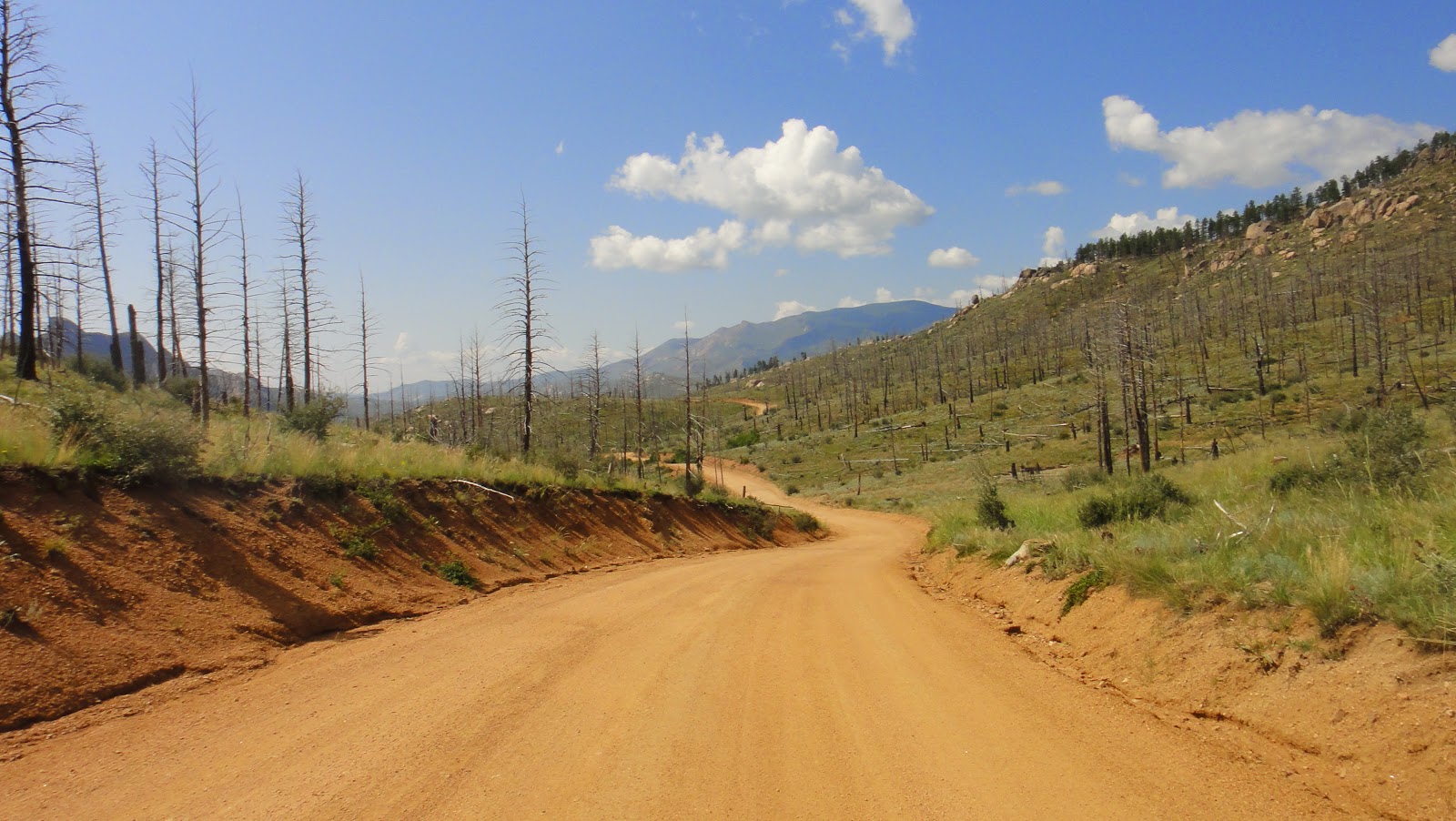
As with segment 2 of the CT a lot of these dirt roads went through the Hayman burn area and they were hot and exposed, and never flat. The up and down nature of the section in the above picture went on forever, imagine going down a bit, then cresting the next small climb, and repeating that literally about 100 times over 50 miles. But, the dirt gave way to asphalt eventually, which made for quicker progress, and increasing cloud cover helped with the temps:


Finally I reached the Tarryall Reservior around 3 PM and knew the Stagestop Saloon and general store wasn't much further ahead. I began to realize my schedule is holding and that I should be there at least an hour before closing. However, it appears I'll have some bad weather soon:

And then the cold rain started in earnest along with a driving head wind. I piled on the rain gear and kept trudging along, looking forward to hot food. At times like these, I start asking myself why I don't just play golf or go the gym like normal people:

Just before I reach the Stagestop Saloon another cyclist passes me going the same direction like I'm standing still. I catch up with him at the saloon and chat briefly with him as he's trying to simultaneously buy food, eat it, and stuff what he can't eat into various pockets. Turns out he was Neil B and he was the front-runner (and ultimately the winner) of the Colorado Trail Race. Here's his bike (I wonder why he runs a Crest rim the back but an Arch in the front?):

I didn't get a picture of the rider though, I was too busy giving him competition in speed eating. Since I wasn't racing I could have a beer too, I tried not to rub it in:

Neil took off pretty quickly, en route to an amazing CTR run. You can read Neil's race report here, he had quite the adventure. I stayed behind, had a second beer along with some ice cream, and chatted with Joe Polk of MTB Cast. What a cool guy and he drove all the way from Georgia to check out the race.

I stopped by the general store for food for the night and next day then took off north again, just behind 3 or 4 other CTR racers who had rolled through while I was resupplying. Thankfully the rain had stopped and appeared to be leaving for good. It was shaping up to be a clear but chilly evening:

At some point, still several miles shy of Kenosha Pass, I turned off the asphalt and navigated through a maze of jeep trails to connect back to the CT on segment 5 just outside of the wilderness:


And then I'm on the CT again, the last several miles on the west end of segment 5:

About 30 minutes in I tore down a short downhill, tackled the following climb, then I heard a faint "yee haw" well behind me. I stopped to look and saw a rider going down the same downhill I just did and loving it enough to yell about it:


He sprinted up the climb and then I recognized him, it was Chris Plesko. I knew him by reputation if not personally, he has single speed records in one or both of the Tour Divide Race and Colorado Trail Race. He was tackling the CTR again on a fully-rigid single speed. There's nothing more fun on a day ride than a rigid single, it adds challenge to the same old boring trails, but to ride one on something as big as the CTR? Insane...

As he flew by I yelled out encouragment and he wanted to know who was ahead of him. All I could share was that Neil B was well out front, plus a few others whose names I didn't know.

Soon the sun started to set as I continued west on the final miles of segment 5:

And then I hit Kenosha Pass where the CT intersects HW 285:

At this point it really struck me how far I'd come. To drive here from my house is a big drive, yet I had gotten here, on a much more indirect route, on a bicycle. Pretty cool, but the flip side is I have a long way to get back home.

As with the night before I pulled out my CT info and saw there was a good water source 3 miles into segment 6, followed by camping. I continued on and met a pair of slightly drunk ladies with their dog on the trail who were camping at the Kenosha campground. I yielded but they stopped too and really wanted to talk a while and know what I was doing. I knew they had to have been drinking to want to flirt with someone as grimy and smelly as I was. With light fading fast, I finally excused myself and set off to find water. I filtered in the dark then walked a bit on the trail looking for a camp spot.

I found one, checked carefully this time for any stealth bivy campers, then set up camp only to discover my tent stakes were missing. My best guess is I left them behind that morning when I stopped to lube my chain. I keep the stakes with all my bike repair stuff in the bottom of my frame bag, in a small gray cuben fiber sack, very light but it blends in with the ground. Guess I'll be buying more titanium stakes then!

Of course my immediate concern was shelter, but at the time the sky was completely clear and it was the night of the Super Moon. Hoping it would stay clear all night, I just used my tent as a ground sheet and threw down my mattress and bag. It was hard to sleep with all the light, but it didn't rain and it was a gorgeous night, with a million stars, a few satellites crossed the sky, and I saw one shooting star. Far better entertainment that watching TV before bed.